Where is the capital of Australia located and what is its name? Sydney or Canberra - which of these cities performs capital functions? To give the correct answers to these questions, let's go on an absentee trip to a distant continent. It was discovered later than America, but before Antarctica. The debate about who was the first European to land on the shores of Australia continues to this day. There is also an ongoing discussion about which city in the country is the most beautiful and convenient for living.
Mainland Australia
A photo of a kangaroo and a koala is a kind of calling card of the Earth. Australia is almost 4.5 times smaller than Africa and only 2.5 times larger than the largest island on our planet - Greenland. On the continent there is a large state - the Commonwealth of Australia. Schoolchildren often find it difficult to answer the question of what is the name of the capital of Australia: Sydney or Canberra? Melbourne or Sydney? And it’s not just the remoteness of the mainland and the country. There are several reasons to think before naming a capital city. Knowledge of the history of the discovery and settlement of the continent by Europeans will help explain the situation.
Key milestones of the first stage in the history of the discovery and development of Australia
During the Great Period, the search for a sea route from European countries to India and China was actively pursued by the Spaniards, Portuguese, and after them the Dutch. Until the beginning of the 17th century, Europe did not know where Australia was. Fragmentary information about the voyages of Portuguese sailors and traders to the shores of an unknown southern land has been available since the 16th century, but little evidence has been collected.
It is known for certain that the navigator from Spain Torres in 1606 passed through the strait south of New Guinea, proving that it was an island and not part of an unknown southern continent. Torres saw, across the strait that now bears his name, the shore of some land (Australia). The Dutch made a great contribution to the exploration of the continent. For a long time it remained unknown how far to the east the territory of the southern continent extended.
To the Europeans, everything seemed unusual in the lands they discovered, located far to the south. First of all, those arriving from the Old World were surprised by the marsupials, the red color of the soil, and the drying up rivers. The most convenient places for settlers from Europe to live were the territories in the east, where moist winds from the ocean are blocked by mountains, and more precipitation falls than in the center of the continent.
D. Cook's voyage and the role of the British in settling the mainland
Known for his voyages around the world, the Englishman James Cook, knowing where Australia was located, set off in 1769-1770 to study the borders of the east coast. Walking along the coast from New Zealand, Cook reached the northern tip of the continent. From that time on, the development of these lands by subjects of the English crown began. On January 26, 1788, the first British colony was founded. Until the end of the 18th century, the internal territories remained poorly studied, which did not prevent the British from laying claim to the entire colonized continent. Nobody then took the opinion of the Aborigines of Tasmania and Australia into account.
There is still an ongoing debate about whether genocide of the indigenous population took place in the historical past of the mainland. There is no doubt about the answer to the question of what language is in Australia. The country is a member of the vast Commonwealth of Nations. Formally, the previous monarchs and the current Queen of Great Britain are the heads of the countries and dependent territories included in this association. In Australia, English is the official language.

Earth's smallest continent: geographical location (GP)
What hemisphere is Australia in? Let's take a look at the map. As you can see, the continent lies south of the equator, that is, it is completely located in the Southern Hemisphere. The main elements of Australia's latitudinal GP are:
- York Peninsula is the northernmost point of the mainland.
- The southernmost position on the continent is occupied by Cape South Point.
- The territory of Australia extends from parallel 10° S. w. to 39° south w.
- The continent is crossed almost in the middle by the Southern Tropic.
Which hemisphere is Australia in: Eastern or Western? The continent is not crossed by the 0° and 180° meridians, which means it is entirely located in the Eastern Hemisphere. The main elements of the Australian GP by longitude:
- The extreme point in the west is Cape Steep Point.
- The extreme eastern position is occupied by Cape Byron.
- Australia lies east of the 113°E meridian. d., west of 153° E. d.
- The total area of the mainland is about 7.659 million km 2.
The continent stretches from west to east for about 4 thousand km. The distance from the north of the continent to its extreme point in the south is about 3.7 thousand km.

Coastline
Mainland Australia is washed by:
- Timor and in the north;
- Coral, Tasman seas in the east;
- bays and straits of the Indian Ocean in the west and south.
To the southeast of Australia is located in the northeast - about. New Guinea. The largest collection of corals on Earth, the Great Barrier Reef, runs along the east coast. The natural “structure” reaches a length of 2 thousand km. Coral reefs and atolls make it difficult to approach the coast of mainland Australia from the east (a photo of one of the small islands is presented below).

Commonwealth of Australia
Until the last decade of the 19th century, Australia included 6 separate colonies with their own authorities, armed forces and other attributes of independence. In 1898, the development of a constitution for the federation of the colonies began. Australians celebrated the first day of 1901 as citizens of a single state - the Commonwealth of Australia.
The rivalry between the cities of the country, which ranks sixth in the world in terms of territory, began more than 100 years ago. The question arose: where will the capital of Australia be located? Sydney or Canberra - which of these cities was preferred? It should be noted that many Australians consider their continent to be the most unusual. Residents of Sydney and Canberra praise their cities as the best. In Melbourne they claim that their city is more picturesque and more popular.
What is the name of the capital of Australia: Sydney, Melbourne or Canberra?
Federal authorities after 1901 were located in the specially created Australian Capital Territory. It was decided that the capital of Australia would be located here. Sydney or Melbourne - these two largest cities could become the administrative centers of the federation in the first decade after its creation. When the discussions ended, it was decided to put an end to the competition that had arisen. Temporarily preference was given to Melbourne. This is the former capital of Australia, where the federal parliament was located for a quarter of a century.
The idea of building a new city took a very long time to be realized on the territory of New, but not in Sydney, but a little further from the coast. Only in 1908 was the location of the administrative and political center of the country finally approved, and in 1911 its design and construction began. Melbourne served as the capital until 1927.
Canberra: foundation and name of the city
Decades have passed since the creation of a unified state on the mainland, and many people still find it difficult to answer the question: “Is the capital of Australia Sydney or Canberra?”
In 1911, a competition was announced to design a new city. It was won by American architect Walter Griffin. The authors of the idea of creating the capital had doubts about its name. The following options were proposed: James Cook, Shakespeare, Olympus, but, in the end, they retained the historical name.
In March 1913, the first stone was laid for the foundation of the city. The name of the new capital came from the village of the same name, Canberra, on the Molongo River. The distance from here to Sydney in the northeast is approximately 280 km, to Melbourne in the southwest - 650 km. The word "Canberra" can literally mean "meeting place" in the Aboriginal language of Australia. The first British settlement appeared here in 1820. A public holiday - Canberra's Foundation Day - is celebrated annually in Australia (the second Monday of March).

Growth, development and current realities of the capital of Australia
Economic turmoil due to World War I delayed construction. It was not until 1927 that the federal parliament of the Commonwealth of Australia moved from Melbourne to Canberra. The capital's growth and development slowed during the Great Depression and World War II. It was only after 1945 that Canberra began to prosper. Its population is about 392 thousand people. In the capital, the unemployment rate is lower and the average income is higher than in the country as a whole. Initially, the project envisaged the creation of a garden city, beautiful and convenient for living. Large areas of natural vegetation have been preserved in Canberra, and new parks and public gardens have been created. The country's Parliament meets in the capital, the Supreme Court and numerous government agencies are located. The historical sites and attractions of Canberra are as follows:
- Parliament buildings (former and current);
- St. Anglican Church;
- St. John's Churchyard;
- National Museum;
- war memorial;
- Australian National University;
- Royal Military College;
- National Gallery.
Features of the administrative-territorial structure and population density
In addition to the territory of the federal capital, Australia includes several regions that differ in area, size and population composition. The less populated and developed territory is the Northern one. In addition, there are 6 separate states: Western and Southern New South Wales, Victoria and Tasmania. The largest regions of Australia by area are Queensland and Western Australia.
The country's largest cities are located on the east coast, which is explained not only by the history of the discovery and settlement of the mainland. From the Pacific Ocean, a mountain range runs along the Australian coast, its average height is 1500-2000 m. This is the Great Dividing Range, which protects the coastal strip from dry hot winds blowing from the central desert regions.

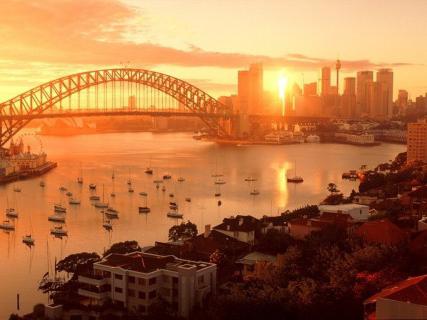
The largest city on the east coast is Sydney. The population of the metropolis is about 4.4 million people. In photographs of the city you can often see the beautiful white building of the Opera House, reminiscent in shape of yacht sails or orange slices. The Sydney Opera House is one of the most beautiful architectural structures in the world - a symbol not only of the city, but of the whole of Australia. The author of the theater building project (Jörg Utzton) took 10 years to implement the complex technical solution. The unusual interior decoration of the opera was called “cosmic gothic”.
Melbourne is located south of Sydney and Canberra and has a population of about 3.9 million people. The city is considered the sports capital of Australia: international tennis tournaments and Formula 1 racing competitions are held here. Melbourne's interesting and distinctive architecture attracts tourists. The city has transformed from a fishing village into a metropolis in less than two centuries.
Brief description of the main socio-economic indicators
An overview of Australia would be incomplete without citing the main demographic indicators and mentioning other important socio-economic features of the country. The total area of the federal state of Australia is about 7,687 km 2. The territory includes not only the mainland, but also a number of large and small islands closest to it. The country's population, according to 2014 data, is 23.8 million people.

Adherents of the Anglican Church in the Commonwealth of Australia account for about 26% of the total population. There are approximately the same number of Catholics and followers of other Christian faiths in Australia. At the time European colonists landed on the mainland, the indigenous population was at a low level of development. The Australian aborigines were engaged in collecting fruits and seeds in the wild, hunting and fishing.
Convicts began to be brought to the mainland from England, and the first colonies and other permanent settlements appeared. From the Old World, pathogens of human and animal diseases came to Australia along with the newcomer population and domestic animals. As a result of disease, the indigenous population declined significantly. Rabbits and other acclimatized herbivores caused great damage to wild flora.
Australia has the richest reserves of natural resources, which are mainly mined in the northern and western regions of the country. Mineral resources include deposits of natural gas, oil, coal, ferrous and non-ferrous metal ores, gold and uranium. Renewable energy sources are used on the mainland: solar radiation, tides, wind. The main rivers - the Murray and the Darling tributary - irrigate agricultural plantations in the southeast. Australia is an important livestock-raising region, with fine-fleece sheep and cattle breeding especially developed here. Investments from local as well as foreign companies are made in the extraction of fossil fuel raw materials (oil and gas). The Commonwealth of Australia is developing its mining and processing industries; raw materials, energy and agricultural products are exported. The country has a developed (service sector).
The role of the main monetary unit here is played by the Australian dollar. In terms of GDP per capita, the Commonwealth of Australia is among the top ten countries, ranking sixth in the world. and the capitals of Oceania attract the attention of tourists. For small island territories, income from this sector of the economy is the main one.

Australia within Oceania
The control of the Commonwealth of Australia extends to the archipelagos and islands: Ashmore, Cocos, Cartier, Macdonald, Norfolk, Christmas, Heard (some of the listed territories do not have a permanent population).
The capitals of Australia and Oceania differ significantly from each other in many respects. Most island countries have a predominant indigenous population. Even the largest sovereign and dependent territories are tens of times smaller than Australia. Thus, the area of the country located north of Australia - Papua New Guinea - is about 463 thousand km 2, the population reaches 7.1 million.
Mysteries of a small continent
Traveling to Australia is attractive to many people, because the mainland is famous for its exoticism. There are many endemic flora and fauna found nowhere else here. As scientists suggest, in ancient times Australia was part of the proto-continent, but due to its split and drift to the southeast, it was removed from other continents. Thanks to isolation in Australia and on the island. Tasmania has preserved relict plants and marsupials, long extinct in Africa and Eurasia.
Based on the results of archaeological excavations, rock paintings, fossil remains of people, and ancient tools, researchers determined the time of settlement of the mainland. Findings indicate that the first people sailed to Australia from other inhabited continents. It is possible that the population has existed here for about 50 centuries, but it is more likely that the first inhabitants appeared about 21 thousand years ago.
Researchers classify the fauna of Australia as a special area, believing that the most ancient animals live in this region of the Earth. It is believed that in the Paleozoic era there were land connections with the Asian part of Eurasia. Back then, the fauna on the mainland was not so diverse. Long before the beginning of the Quaternary period, marsupials came to Australia. Around the same time, the final separation of the continents took place. Predators - representatives of higher mammals - were no longer able to penetrate into Australia. Therefore, they are not typical for the indigenous fauna of the continent we are considering. The oldest placental mammals - the platypus and echidna, and marsupials - kangaroos, koalas and other unusual animals are found in Australia.
“Theme Australia” - I’ll catch it anyway. Lesson topic: “Natural areas of mainland Australia.” And the Little Koala sleeps sweetly on the branches. Coat of arms of the Commonwealth of Australia. The ostrich runs merrily, the shadow has become shorter. Color in natural areas on a contour map. Purpose of the lesson: Lesson topic: “Natural areas of Australia.” Homework. Create a crossword puzzle: “organic world of Australia.”
"Australia 7th grade" - Learning new material. Australia and Oceania. Lesson topic: Australia. Geographical location, history of the discovery of the continent. Relief and minerals. Geographical location, history of the discovery of the continent. Organizing time. Lesson progress: Lesson summary. Australia. General plan for studying the mainland: 1.Geographical location, history of the discovery of the mainland.
“Australia theme” - At first, the British government sent convicts there. There are no large deep rivers. Why is Australia the driest continent in the world? Length 2375 km. What minerals is Australia rich in? Australia was discovered by Europeans later than other continents due to its remoteness. Tell us how Australia was discovered and developed. What is the continent’s topography characterized by?
"Districts of Australia" - European settlers. Australia has a very low population density. Relocation to dry areas and population decline. Growth in numbers. Equal citizens of their country. Decorative creativity. Aboriginal Australians belong to the Negroid-Australoid race. The east of Australia is the main area of residence.
"Project Australia" - Project goals. Creative name. Annotation. Project stages. Educational: fostering a respectful attitude towards the culture of the country of the language being studied. Fundamental Question: Is everything upside down upside down? Duration – 4 lessons. Problematic question What do we know about Australia? Educational: expand students' knowledge on the topic "Australia".
“Discovery of Australia” - In 1605, 3 ships under the command of Pedro Fernandez de Quiros set out from Callao in search of the Southern continent. The expedition discovered land, which was mistaken for the Southern Continent and called Australia Espirito Santo. In 1642, the ships Heemskerk and Zehain, under the overall command of Abel Tasman, left Batavia towards the Southland.
In 1901, the Australians decided to build a new capital of Australia - the city of Canberra. We spent almost ten years choosing the location.
As a result, they decided to build a new city on the route between Sydney and Melbourne in a picturesque area on the shores of an artificial lake. The name chosen for the new capital was Canberra, which translated from the Aboriginal language means “meeting place.”
Like any other capital, Canberra is home to parliament, the supreme court, ministries and banks.
History of the Australian capital
For some reason, many now consider Sydney to be the capital of Australia, and some even call Melbourne. And this is absolutely not true, although it could be so. These cities are the largest in Australia not only in terms of population, but also in terms of the location of the cultural centers of this southern continent. Both Sydney and Melbourne claimed the right to be the capital, but after the declaration of Australian independence in 1901, the Australians decided to build a completely new city for their capital.
A special international competition was announced for the best design of the future capital. It was won by the American architect and designer Walter Burley Griffin. By the way, Griffin received 1,750 pounds and three shillings for his project.
The government of the country officially appointed Walter Griffin as the general director of the planning and design of the capital, and under his leadership the new city was built. In general, Griffin's layout and design concept was retained, although the design was modified somewhat during construction. Griffin was very disappointed that his brilliant idea was not realized, and left Canberra in 1920, but the city continued to be built and developed. Already in 1927, the first meeting of parliament was held in Canberra. But it took many more years for the city to look like what Walter Burley Griffin wanted to build.

It took a long time to choose a name for the new capital. There were many options, such as: Kenguremu, Engirskot, Melandiperbane, Sidmeladperbrisho, but settled on the proposal of Lady Denman, the wife of the Governor-General of Australia, Lord Denman, to name the new capital Canberra, which in the Aboriginal language means “meeting place” or “meeting place” . Since then, Canberra Day has been celebrated every year on the second Monday of March.
This is what Kurrajong Hill looks like now, which is now called Capitol Hill, where on March 12, 1913, Lady Denman officially announced the name of the future capital of Australia.

Layout
The layout of Canberra is very smart and thoughtful. This is truly a business city providing its residents with excellent living conditions. The modern Canberra city center is divided by two perpendicular axes: the water axis, which runs along Lake Burley Griffin. And the land axis runs from southwest to northeast from the Houses of Parliament to Mount Ainslie, at the foot of which there is a war memorial. The city consists of two sectors - the northern, where the commercial part is located, and the southern - Capital Hill, where the Australian Parliament building is located on Kurrajong Hill. The government center and residential areas are connected by a network of expressways. Moreover, they are pre-designed to ensure their high throughput. Even if the number of residents increases several times, there will be no traffic jams here.

The central part of the city, known as the "Parliamentary Triangle", is formed by three wide streets: Commonwealth Avenue, Constitution Avenue and King's Avenue. The city uses a zonal structure, in which, in addition to the city center, seven districts are clearly distinguished, which in turn are divided into districts. Each district has its own community and commercial centers. The location of suburbs, nearby villages and industrial areas has been determined. None of them interferes with the other, and at the same time they have a clearly established system of interaction. Moreover, they are built up and populated not chaotically, but systematically with an even load of city communications, which are built before the construction of the area begins.
- The North Canberra district consists of 15 districts built from 1920 to 1960.
- The South Canberra district consists of 12 districts and was settled over a 40-year period from 1920 to 1960.
- Woden Valley District, 13 districts, settled in 1963.
- Belconnen District, 25 districts, first settled in 1967.
- Weston Creek County, 8 wards, settled 1969.
- Tukkeranong District, 19 districts, settled in 1974.
- Kungahlin District, 7 districts began to be settled in 1990. Currently expanding.

The districts of North and South Canberra were built according to the plan of Walter Burley Griffin. In 1967, the Y-Plan, a plan for the future development of Canberra, was adopted by a special commission for the development of the capital. New housing estates are being built around a series of “town centers,” again connected by expressways. On the plan it looks like a Y, with Tukkeranong County at the base and Belconnen and Coongahlin counties at the branches.

Almost all districts have their own large shopping centers, which serve several neighboring districts, although the districts themselves have many shops, cafes and boutiques. Schools, children's and health care institutions, and public utilities are usually located near shopping centers. It is noteworthy that Australians cherish their history and therefore many areas of Canberra are named after former Prime Ministers of Australia, famous people of the country, or early settlers who settled in these areas. This is a kind of fountain-monument to Captain Cook.

Canberra's development and all urban planning and land use matters are controlled directly by the government. Everything is based on monetary calculations. So the land on which Canberra is located is leased from the state for a period of 99 years and the city authorities contribute the cost of the lease to the national government budget.

Canberra is a very green city. For less than four hundred thousand residents of the capital, there are more than 8 million trees. Green areas inside the city organically fit into the natural landscape of the area and give it a unique appearance

Attractions
The attractions of Canberra are: the national library, the national gallery of Australia, and a large number of museums. Australians have not forgotten about relaxation. There are many different cultural and entertainment centers, parks, sports complexes and wonderful recreation areas in the suburbs.

Each district has stadiums and sports complexes in which not only various sports events are held, but all residents of the city can play sports.

Jogging tracks are equipped along the reservoirs, and the reservoirs themselves are used by water sports enthusiasts, of whom there are many here.
So Canberra became an exemplary example of urban planning, a real city of the future.
Canberra is the capital of Australia. A city that is located in the center of the continent, but despite this, surrounded by colorful nature and picturesque beautiful landscapes.
The city is a little over a hundred years old, but it is quite modern and developed, so the number of people wishing to move to Canberra permanently is growing every year.
Canberra was founded in 1908. Before the construction of the city began on this site, the indigenous people of Australia lived here.
In 1820 Residents of European countries came to Canberra for permanent residence. Within three years there was a sheep farm and estate in Canberra.
All 19th century the future capital of Australia was inhabited by European residents, and the population grew every year.
When at the beginning of the 20th century There was a question about choosing a new capital of the continent; Canberra was out of the question. The main contenders for this title were cities such as Melbourne and Sydney.
After much debate between these then largest Australian cities, it was decided to build a new city, which would become the capital of Australia. It was from this moment that the development of Canberra began. Already in 1913 this city gained the status of the capital, and the government moved here in 1927.
It is important to know! A powerful economic leap in Canberra's history occurred after the Second World War.
Today the city of Canberra is one of the most original and convenient megacities Australia. As for the name, it comes from the indigenous Aboriginal word “kanbarra”, which means “meeting place” or “gathering place”.
Geographical location and climate of the city
 Canberra's area is 814.2 km². The city is located in the southeast of the country, near the Brindabella Mountains. To the coast - 150 km.
Canberra's territory is located on a hilly plain. The highest point in the capital is Mount Majura. The city is surrounded by eucalyptus forests and ponds.
Molonglo is a river that flows through Canberra and is dammed to help maintain sufficient water levels in an artificial central lake called Burley Griffin.
Canberra Climate tropical continental. That is why the temperature can change significantly over the course of a day. Summer in Canberra (December, January and February) is hot. Temperatures range from +20 to +27 °C.
As for winter, which takes place here in June, July and August, the thermometer may drop at this time of year even down to -10°C. The foothills are covered with snow in winter. It rains in spring and summer. In general, there are about a hundred rainy days in Canberra a year.
Transport
 In Canberra, local residents mostly drive their own cars. The road system here is convenient, and the streets move in a circular pattern.
Those who prefer to ride bicycles in the Australian capital also feel at ease, as bike paths are everywhere here.
Those who do not have their own transport use public transport. Thus, the most popular way of transportation in Canberra is Action buses. The route network covers both the city center and its suburbs.
Also in Canberra you can take a taxi. The prices are reasonable, and you can call a car by phone or by catching a car on the street.
City layout
Since Canberra was built with the expectation that it would become the capital, this city is as thoughtful as possible.
Canberra's interesting layout was designed by one of the most famous American architects of the 20th century Walter Burley Griffin.
Central part of the city built on a ring system. There are two axes: land and water.
The rest of the city is based on three hills: Black Mountain, Bimbery and Ainslie.
Canberra has a certain structure: urban centers, counties, industrial villages and districts, and suburbs. The city has seven districts:
- North Canberra;
- Weston Creek;
- Tuggeranong;
- Woden Valley;
- Belconnen;
- South Canberra;
- Gungahlin.
What is also unusual is separate thematic streets. For example, streets in the Duffy area are named after Australian dams and dams, and streets in the Page area are named after famous naturalists and biologists.
Population of Canberra
Lives in Canberra almost 400 thousand people. A little more than 1% of indigenous people live in the capital. Most of the population consists of people who were born outside the continent. The average age of Canberrans is thirty-two years.
Lives in the city large number of immigrants from the UK, New Zealand, Italy, Vietnam and Germany. In recent years, people from South and East Asia have been coming to Canberra for permanent residence.
It is important to know! There are many Russian-speaking residents in Canberra - several hundred people.
The capital of Australia, Canberra, which has a young population, is a city that in its short history has managed to become a progressive and highly developed metropolis. Here high quality of life, convenient transport system, comfortable accommodation and, of course, picturesque Australian nature!
In conclusion, we invite you to look exciting video about the capital of Australia – Canberra:
The name of the capital of Australia is translated from the local Aboriginal language as “ meeting place" The city's population is just over 345 thousand people. Canberra is one of the largest cities in Australia and is located near the Brindabella Mountains, 150 km from the east coast of Australia.
The capital of Australia is located at an altitude of 550 to 700 m from sea level. The Molonglo River flows through Canberra, dammed in one place to maintain the water level in the artificial Lake Burley Griffin, located in the city center.
Canberra Parliament
History of the formation of the capital of Australia
The search for a site for Australia's national capital began in the 19th century with debates in the Federation of Australia. It was assumed that the federal government would be located in Sydney, which remained the administrative center of the colony until 1840. However, the gold rush that broke out in Victoria led to a change in this opinion, since by 1860 the population of Victoria had outgrown the population of Sydney.

Another city that claimed the title of capital of Australia was Melbourne, whose financial base, also due to the discovery of gold deposits, at one time amounted to about 5% of the total income of the British Empire. As a result, a point came when the city's size and economic influence became comparable to that of Sydney, and Melbourne was given additional administrative powers.
At the first discussion in the Australian Federation, many proposals were made regarding the location of the future capital of Australia. Thus, John Dunmore Lang, a politician who had previously advocated the creation of the Australian Federation, proposed Sydney; however, the Premier of New South Wales, Henry Parkes, made a proposal to locate the capital of Australia on “neutral territory”, namely, in the city of Albury, located on the Murray River, which flows along the border of Victoria and New South Wales.

In 1898, a popular referendum was held on this issue in four colonies - New South Wales, Victoria, South Australia and Tasmania. The last three colonies received the required number of votes, but New South Wales did not. For this reason, in the same year, an additional meeting of four prime ministers was held, during which George Reid proposed to the Prime Minister of New South Wales to form a new capital of Australia on the territory of his colony.
The proposal was supported by three other premiers, after which an amendment was made to the content of Section 125 of the Australian Constitution to create the national capital of Australia in the state of New South Wales. Moreover, in a note to the amendment it was noted that the location of the future capital should be no closer than 100 miles (160.9 km) from Sydney. With the passage of the bill, Melbourne became the temporary "home" for the government until a location for a new capital could be found. In 1899, the revised bill was successful, receiving a majority of votes in a referendum.

However, the question of the exact location of the new capital remained open. The town of Bombala, located in far southern New South Wales, was originally proposed. Later, at the proposal of the Prime Minister of New South Wales, the cities of Monaro, Orange and Yass were added to the list. The first Prime Minister of the Federal Government, Edmund Barton, added the cities of Tamworth, Tumut, Albury and Armidale to the list.
In 1902, members of the government visited all the proposed cities to determine their suitability for the new capital of the country. This trip did not bring any results, and it was decided to refer the matter to a Royal Commission, which proposed choosing Tumut or Albury.

In 1903 the Commission submitted a report to Parliament recommending, in order of priority, Albury, Tumut and Orange. The final choice was never made, as the House of Representatives favored Tumut and the Senate preferred Bombala. Soon the existing parliament surrendered its powers, and the choice of the site of the new capital of Australia passed to the new parliament.
In 1904, at a meeting of the new parliament, a compromise decision was made - parliamentarians chose Dalgety, which, like Bombala, was located in the Monaro region. However, this decision of the Federal Parliament was not supported by the New South Wales government, due to the reluctance to allocate significant areas required by the federal government.

In 1906, the New South Wales government nevertheless made some land concessions, but with the condition of organizing a new capital in the area of the cities of Canberra and Yass and closer to Sydney. After a tour of the region by some senators and members of parliament, a new list of 11 cities was presented to parliament in 1908.
Dalgety initially took the lead, but by the eighth round Canberra and Yass took the lead, and in the ninth round they were confirmed as the site for the future capital. The Act of Government Meeting of 1908 overturned the previous decision of 1904 and established the formation of the capital of Australia in the area of the cities of Canberra and Yass.

That same year, government-appointed surveyor Charles Scrivener arrived in the region and, after extensive research, settled on Canberra's current location, 300 km (186.4 miles) southwest of Sydney in the foothills. Australian Alps.

Canberra plan
Construction of Australia's Capital began in 1913 according to plans by American architects Walter and Marion Griffin, who won an international competition to design the city.
The architectural design of the capital of Australia was based on the concept of a park city, providing for extensive areas of natural vegetation. Canberra was built on the basis of an urban plan designed by an American architect Walter Burley Griffin, one of the largest

Opening of the Australian Parliament House in 1927
That is why Australians proudly call their capital “bush capital,” which means “bush capital.” Currently, Canberra is a thriving city, home to the Parliament and Supreme Court of Australia, numerous government agencies and ministries.
Development of the Australian capital
In 1911, the Royal Military College was opened on the Duntroon site, one of the first federal facilities in the Australian Capital Territory. The opening of the college was due to the need to train officers for the new Australian army, the newly created Australian Federation.
In the same year, an international competition was announced to develop the design of the future capital. In 1912, the winner of the competition was the American architect Walter Burley Griffin. Griffin's design, introduced by his wife, also an architect, Marion Mahoney Griffin, was replete with geometric patterns formed by hexagonal and octagonal streets radiating from several centers. The lake, framed by extensive natural vegetation, was chosen as the center of the city's architectural composition. As the press of the time put it, Griffin's design was "the best presented yet, with attractive simplicity and clarity."
The geometric layout of the city, including lakes, was tied to various natural topographical landmarks. Moreover, the project took into account coordination with the geometric axes of federal buildings and natural attractions.
For the practical implementation of Griffin's project, the government brought in Scrivener, who proposed to simplify the geometric shapes of the project. Scrivener's proposal was rejected by Griffin, who stated that his chosen geometry was "one of the raison d'etres of ornamental waters" and refused to approve the simplified Canberra development plan.

The official name of Canberra was approved on March 12, 1913, at the very beginning of its construction. Having received Griffin's official refusal to approve the plan, the government invited him to Canberra to resolve the issue. On his arrival in Canberra in August 1913, Griffin was appointed director of design and construction for the city for a period of three years.
Griffin's work was delayed by numerous bureaucratic delays, to eliminate which, in 1916, a Royal Commission gave Griffin additional powers.

Griffin's strained business relationship with Australian authorities and insufficient federal construction funding led to Griffin being fired from his position and leaving Australia. By the time of his dismissal, Griffin had only revised the plan to supervise the excavations on the main avenues and created the Glenlock Cork Plantation.
Following Griffin's departure, advice to the building authority was assigned to the newly created Federal Capital Advisory Council. The committee's successes were insignificant, and in 1925 it was replaced by the Federal Capital Commission.
The main purpose of the commission was to move the Commonwealth Parliament and federal services from Melbourne to Canberra. On May 9, 1927, the federal government officially moved into the Preliminary Parliament House. Then gradually, over the course of several years, the headquarters of various departments moved to Canberra. Between 1938 and 1957, development of the city continued under the direction of the National Capital Planning and Development Committee for Canberra.
Several of the city's major buildings were built during this time period, including the Australian War Memorial (1941).

During the Great Depression and post-war period, Canberra developed slowly and rightly earned a lot of criticism for the ugly disorganization of many of its buildings. It is no coincidence that Canberra has often been compared to “several suburbs in search of a city.”
Prime Minister Robert Menzies made a great contribution to the development of the city. Over more than 10 years of his leadership, Menzies fired 2 careless ministers and brought Canberra to a high level of development.

In 1954, the Senate Select Committee heard Canberra's development problems and, given the severe shortage of housing and office space, recommended the creation of a single body that would combine planning with executive functions. So in 1957, the National Capital Development Commission was created, which, after four years of debate about the design and shape of Lake Burley Griffin, finally completed its construction in 1964. The completion of these works laid the foundations for the development of the Parliamentary Triangle.
Over four decades, a number of buildings of national importance have been built on the shores of the lake. According to the government's plan, "the lake is not only the centerpiece of Canberra's master plan, but also forms the 'front' side of the National Parliamentary Precinct." The newly built Australian National University has been developed on the northern shore of the lake and several sculptures and monuments have been installed here.

At the end of construction, the central pool was located between the war memorial and the Houses of Parliament, and a landscaped boulevard was located along the banks. The Parliamentary Triangle was home to the New National Library of Australia, followed by the Supreme Court of Australia, the National Gallery and the new Parliament House. In 2001, the National Museum of Australia was built on the shores of the lake (to replace the demolished Royal Canberra Hospital).
According to average estimates, in the period 1955-1975. Canberra's population increased by more than half every five years. The provision of housing for new residents of the city was controlled by the National Capital Development Commission, which oversaw the introduction of new residential areas in the districts of Woden Valley (1964), Belconnen (1966), Weston Creek (1969) and Tuggeranong (1973). . In 1988, this Committee was disbanded and replaced by the Government of the Australian Capital Territory and the National Capital Authority, specifically created to oversee the Commonwealth's efforts to develop the national capital. In 1990, Canberra's development continued with the formation of the Gungahlin area.
Cultural life of the capital of Australia
Canberra is also a significant educational and cultural center of the country. Canberra has many monuments and social and cultural institutions. Among them: Australian War Memorial, National Gallery of Australia, National Portrait Gallery, National Library of Australia, National Museum of Australia, etc. Cultural attractions in Australia's capital include the James Cook Monument, the National Carillon, Telsra Tower, Black Mountain Botanic Gardens, the National Scrivner Dam Zoo and Aquarium, the National Dinosaur Museum and the National Science and Technology Centre.
Canberra can rightfully be called the musical capital of Australia: the Canberra Theater hosts major concerts and theatrical performances, and musicians' performances at Llewellyn Hall at the School of Music of the Australian National University are also significant. Childers Street is home to a street theater and Canberra's oldest concert hall, the Albert Hall, opened in 1928 and was originally home to the Canberra Repertory Society and the Canberra Philharmonic.
Modern city
The early years of the 21st century in the Australian Capital Territory were marked by a long drought that caused several devastating bushfires. For example, in 2001, during the Christmas period, five local fires burned 16 km² of forests, including pine forests, in which the government had invested many millions of dollars.
A horrific fire in 2003 destroyed vegetation across 70% of the state, including 99% of the Tidbinbilla Nature Reserve and significant areas of state pine plantations. The fire killed four people and completely destroyed 67 houses, of which: 16 houses from Uriarra, 12 from Pierces Creek; 614 houses in Canberra's suburbs were also partially destroyed.
Historic buildings also burned down: the Mount Franklin Alpine Chalet, built in 1937-1938. for the Canberra Club, the Neil Desperandum and Rock Valley buildings at Tidbinbill Nature Reserve, most of the buildings at Mount Stromlo Observatory, including the Oddy Telescope, built in 1911 and the first federal building in the state.
The nightlife of the Australian capital is also varied - in the Dixon and Kingston areas there are a large number of discos, bars and nightclubs.


Among the cultural events, it is necessary to highlight: the National Folk Arts Festival, the Royal Canberra Show, the Summernats Car Festival, the Canberra Multicultural Festival and the " Celebrate Canberra».